Club Benefits


Those of you who remember driving before Google Maps, or any kind of GPS navigation, will know just how incredible a service it is. As long as you have a cell signal, it's now almost impossible to get lost or struggle to find where you need to go. But there's a lot more to Google Maps than simply getting from point A to point B.
Google Maps has a bunch of features hiding under the surface you may not know about. Some of them involve different ways to navigate, but others have absolutely nothing to do with travel at all. Some of them even help you avoid getting into your car in the first place.
I regularly find myself taking advantage of Google Maps features that have absolutely nothing to do with giving you directions — and here are 11 of my favorites.

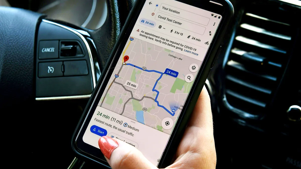
While Google-owned Waze might be the king of incident reporting, you can still make roadborne problems known in Google Maps while you're driving. To get started you'll need to tap the Report button, which looks like a speech bubble with a "+" in the middle.
From there you'll have the option to report crashes, speed traps, traffic slowdowns, construction, Lane Closures, disabled vehicles or obstacles in the road plus the presence of any police activity. If enough people make similar reports, you'll see it start to show up on Google Maps for all passing drivers.
Report road hazards and crashes (Just like Waze)

One-handed gestures
Google Maps can seem difficult to navigate without two hands, but it is possible to control the interface without having to stop what you're doing — which is especially useful when you're driving.
You can zoom in by double-tapping the screen and moving your finger up and down. Or you can change the orientation by spinning your index finger and thumb together on the screen. Finally, if you feel the need to change your perspective, swipe up and down with two fingers together.
Help with parking

If you're struggling to find a parking lot that actually has space, you only need to turn to Google Maps for help. Not only can Google Maps tell you how much room certain parking lots have while you're navigating, you can also pre-book your parking ahead of time — just tap the Book icon and Google Maps will show you links to the services that can get your spot reserved.
Of course if you're likely to forget where you parked, there's a feature for that too. Simply press and hold the blue location icon on the map to force the Your Location menu to pop-up. Then tap the Save parking icon, and Google will drop a yellow pin pointing out roughly where you parked. Just remember that how exact it will be will depend on the GPS signal. The Pin will also only last 24 hours, unless you remove it sooner.
Share your location with others

You don't need to send people an ETA and then have to update them if circumstances change. You can use Google Maps to share your location, or your journey progress to keep them updated in real time.
This only works if you're in some kind of navigation, admittedly, but it's easy enough to do. Swipe up from the bottom of your phone and select Share trip progress. Then choose a contact or app to send the generated link to. Sharing will end when you arrive, but you can end things sooner by following the same steps and selecting Stop sharing.
Change your vehicle avatar

No need to have a boring default arrow on your Google Maps, especially now that Google has a whole range of alternatives for you to choose from. You need to start your navigation and tap the existing icon on screen. This will bring up the Driving Avatar menu with a bunch of different vehicle options to choose from — some of which can even change color.
Ask Gemini for inspiration

Like just about every other thing Google offers, Gemini has come to Google Maps in a variety of different ways. The one I like the most is to ask the AI for inspiration, in case you're either in an unfamiliar area or just need something to do.
All you need to do is type a prompt into the search bar for Gemini to get going. Examples Google uses include "fun winter activity in Seattle" or "interactive date nights in SF." Really, though, the opportunities are endless, and there's nothing stopping you from asking for dinner suggestions, good places to hang out, or anything else you can think of.
Time travel in Street View

Google Street View gets updated pretty regularly, but the older photos don't get deleted. They're still accessible through a feature Google calls "time travel."
On mobile devices, simply load up Street View and tap See more dates at the bottom of your screen. This lets you see a whole list of Street View photos from the past, and navigate as though they were the most recent offerings. Things work in a similar manner on desktop, but the See More Dates option will be on the top left side of your screen.
Find a ride share

You don't even have to drive yourself around. Google Maps can help you summon either a ride share or, in some areas a taxi, to get you where you need to go. Simply start setting up your journey as normal, but instead of picking the car, walking, or the other options, scroll to the very end and choose the ride-hailing symbol. It's a figure with a raised hand and a suitcase.
This will show you which ride share and cab services are available, how far away they are and roughly how long the journey will take in current conditions.
However the booking isn't made in Google Maps, and you may need to download a third-party app. But if you have multiple ride share apps on your phone, this little tool will help you pick the most convenient service at any given time.
Order groceries

If you need some food in your pantry pronto, and don't want to do the shopping yourself then you can order some groceries through Google Maps too. It only works for select chains, such as Kroger (including Fry's, Ralphs and Marianos), Albertson's, ShopRite, and Stop & Shop.
Simply find the supermarket in question and tap Place an Order. Google Maps will then redirect you to a third party, either the grocery chain itself or a food delivery service like Uber Eats or Instacart, for you to carry out your purchase.
However if you do opt for a pickup, Google can inform the store about your ETA, which means your order should be ready soon after you arrive.
Find EV chargers for your car

Did you know that Google Maps has made it a lot simpler to find a place to charge your electric car? Not only can you search for nearby chargers from the search bar Google Maps can highlight compatible chargers while you're driving.
Google is capable of getting real-time information from chargers, so as you're driving by you'll be able see how many chargers are actually available for you to use.
Though it helps if Google knows what kind of car you have, and which chargers it's compatible with. So head into Settings > Your Vehicles > Select Electric and then choose the appropriate charger types.
Measure distances

You don't need to set up a navigation session to figure out how far away something is. You can just measure distance inside Google Maps, and not just in a single straight line either. Individual lines are measured as the crow flies, but you can chain them together to measure out much longer distances.
On mobile, Google will only tell you the total distance, not the distance between individual points, whereas desktop will show you both.
On mobile you do this by pressing and holding your finger against the map, then selecting Measure Distance on the pop-up menu. From there you navigate the screen as normal and press the blue Plus icon whenever you find a new spot to measure to. On a desktop right-click a spot and select Measure Distance. This will set your start point, and each subsequent click on the map sets a measurement line.
More from Tom's Guide
- New leak could have spilled all the Pixel 10 Pro Fold specs — here's what to expect
- Massive Apple leak just revealed 10 new products — Apple Watch 11, new Apple TV, new iPad mini and more
- I tested Waze vs. Google Maps for a weekend trip — and there's a clear winner