I use Maps every day on my iPhone, and these are the 7 features I turn to again and again
Get more out of iOS Maps
I know the world is filled with fans of Google Maps and Waze, but when I need to find out where I'm going, I turn to Apple Maps on my iPhone. I think Apple's made great strides in recent years to improve its mapping tool, and I like having Siri provide me with turn-by-turn directions when I'm driving and have my iPhone connected to my car's stereo system.
Because Maps is my go-to choice for going places, I've picked up a few tricks over the years that help me get the most out of the app. Maybe some of these features are already known to you — at least one of them is included in a look at Apple Maps tips and tricks by my colleague Tom Pritchard. But if any of them are unfamiliar to you, I think putting them to use will make you more appreciative of iOS Maps.
Here are my seven top Maps features for getting directions, looking up places, and more.
Set your preferences
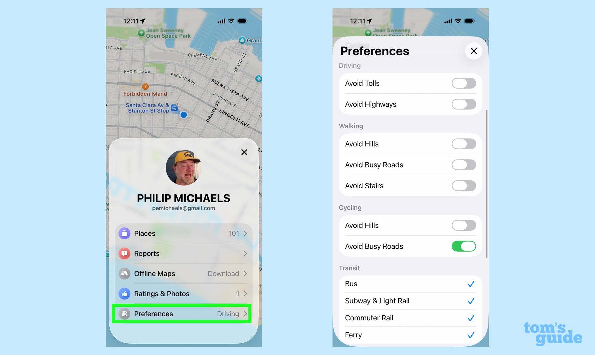
You've probably noticed that Maps defaults to giving you driving directions by car when you ask how to get from Point A to Point B. But it doesn't have to — you can go set your preferred method of directions within the app, which can be really handy if you travel more by public transit, bicycle or foot than you do by car.
Next to the search bar in the main Maps interface, tap your user icon and select Preferences from the menu that slides up from the bottom of the screen. The method of directions — driving, walking, transit or cycling — is the very first thing you can set.
But it's not the only preference you can adjust. Each type of direction has its very own preferences that you can toggle on and off. Don't want to head up any hills on your walk? Want to avoid busy roads when on a cycling jaunt? Hate toll roads when you drive? You can let Maps know all of these things.
Preferences are especially key if you use a lot of public transit, like I do. I've set my Maps app to include all methods of transit — even ferries — so that departure times and stops are included when I need directions.
Get instant access to breaking news, the hottest reviews, great deals and helpful tips.
Get a weather report for where you're going
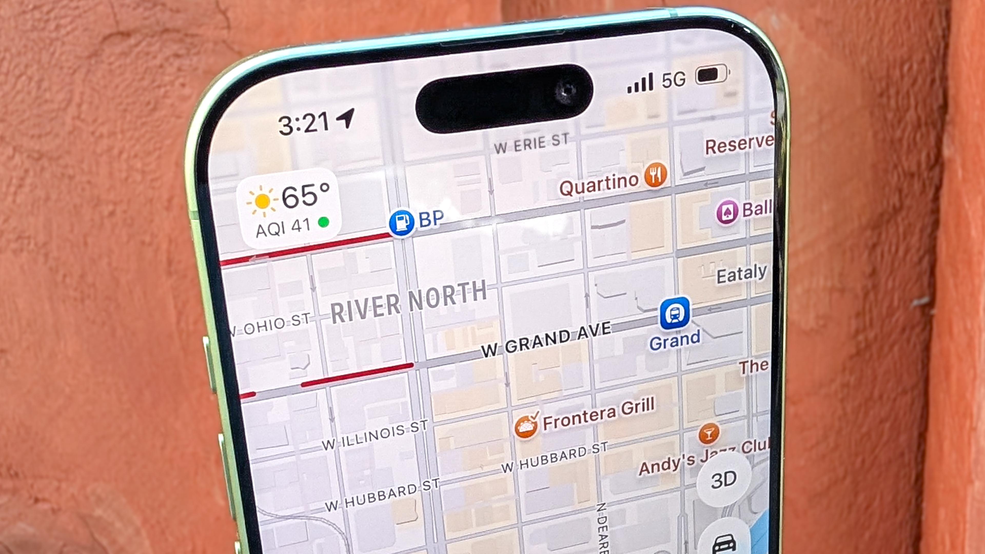
Just because the weather's nice where you are doesn't mean it won't be nasty where you're headed. But rather than leave Maps for the Weather app to get a forecast for your destination, just access the weather directly within Apple's mapping tool.
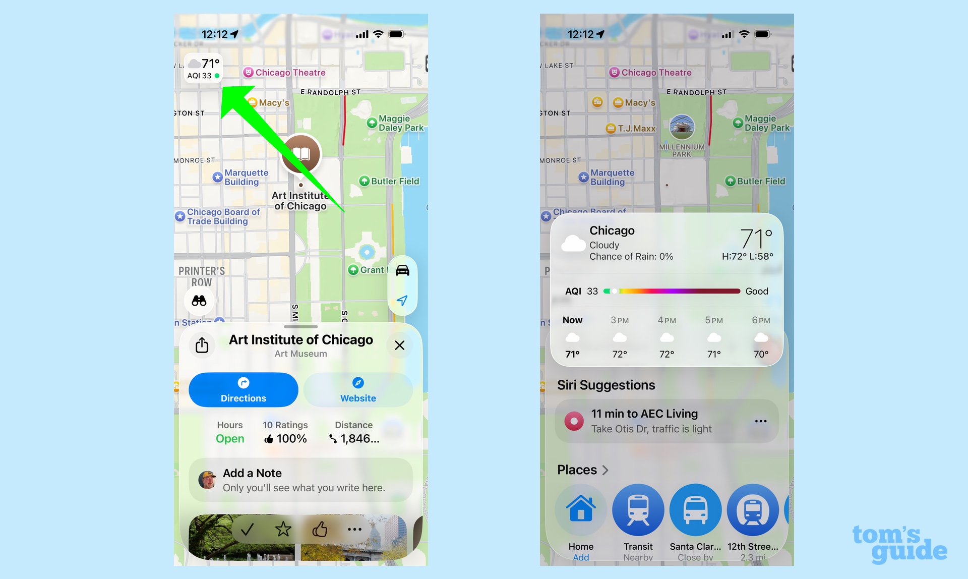
The upper left corner of the map view includes the current temperature and Air Quality Index for whatever location is displayed. Even better, if you hold and press on that temperature bug, you'll get an extended forecast with temperatures for the next 12 hours and whether there's any rain or inclement weather in the forecast.
Make notes about the places you've visited
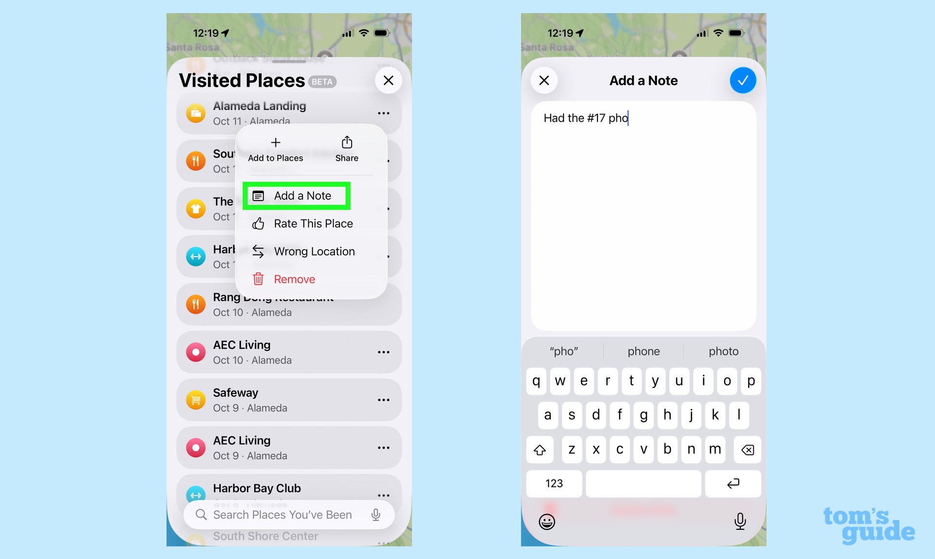
iOS 26 introduces a new feature to Maps called "Visited Places." If you opt in, Maps will automatically log the places you visit, so that you can easily recall the name of that restaurant you enjoyed or find out the location of that particularly helpful repair shop.
I've written about my Visited Places experiences and how I generally like the feature, even if it needs some fine-tuning. (It doesn't have to log every one of my visits to my mom's apartment complex, for example.) But there is a component of Visited Places that I really like — the fact that you can leave notes about each place.
Tap your user icon, and then pick Places from the menu that appears, followed by Visited Places. From the list of places that appears, tap on the More option of the specific place you want to make a note about. (Those are the three horizontal dots to the right of the place's name.) A menu of options appears where you can add a rating, correct the location, share the place with others and add a note.
I find this capability useful because it allows me to make notes of things that might otherwise slip my mind. A local hardware store I use offers knife-sharpening services once a month — I've used the notes feature in Visited Places to jot down where that is. I've also amended restaurant entries with dishes that I've tried and liked, so the next time I'm back at that pho place I ate at last week, I know the specific item to order.
Plan a mult-istop route
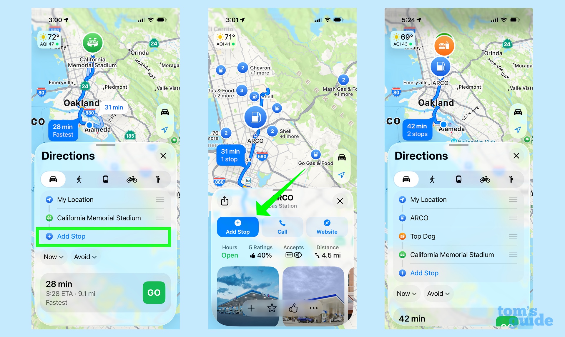
iOS 16 added a multistop route planning feature a few years back, and it's worth revisiting if you're the type of person who likes to cram multiple errands into one drive. For instance, the other week, I was helping my daughter with a project where I had to drive her around town to pick up unused art supplies from assorted donors. With multi-stop routes, I could plan out a journey that didn't have me zig-zagging back and forth while sparing me from punching in new start and stop points at every location.
All you have to do is enter a destination like normal with your mode of transit set to Car. There'll be an Add Stop just under your destination — tap it to search for whatever place you need to add to your route. You can then drag and drop the different stops to optimize your journey.
If I have a complaint about multi-stop routes, it's that the feature doesn't work with travel modes like public transit or bicycling. Maybe that's something Apple can add in the future.
Try a different view
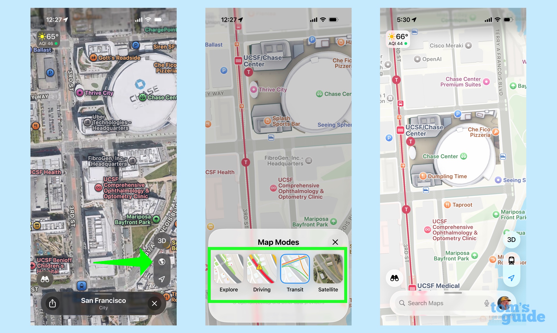
Maps offers different views, and the one I favor tends to vary by how I'm using the app. When I'm driving my own car, I want the Driving View, as it displays traffic conditions and road hazards. But the Transit view can be helpful if I'm in a new city and need to know where the nearest subway station or bus stop is. Similarly, Explore or Satellite can help acclimate you to your surroundings if you're just walking around on foot.
The icon to switch your view appears in a vertical row down the right side of the screen, just above the search bar, with the icon changing depending on what view you happen to be in at the time. Explore has a foldable map icon, while Driving and Transit feature cars and trains, respectively. The Satellite view uses a globe for its icon. Any time you want to switch your view, just find the icon, whatever form it happens to be in, and give it a tap.
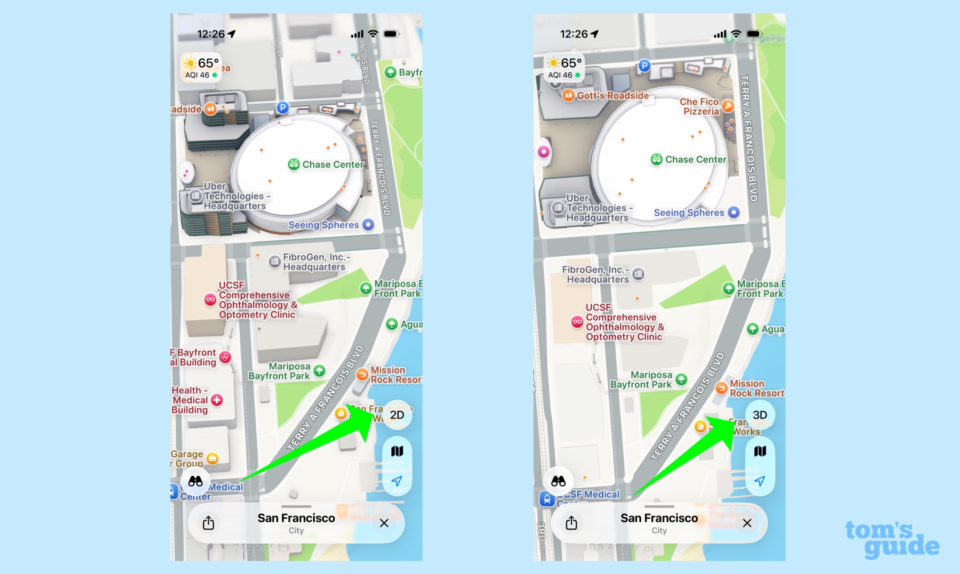
By the way, just above that icon, you have the option to switch between a 2D and 3D view. The 2D look is more like a traditional map with its overhead view, while 3D adds a little bit of depth. Because it shows the outline of nearby buildings, you might find it helpful for pinpointing exactly where you are in the real world relative to Apple's mapping app.
In dot we trust
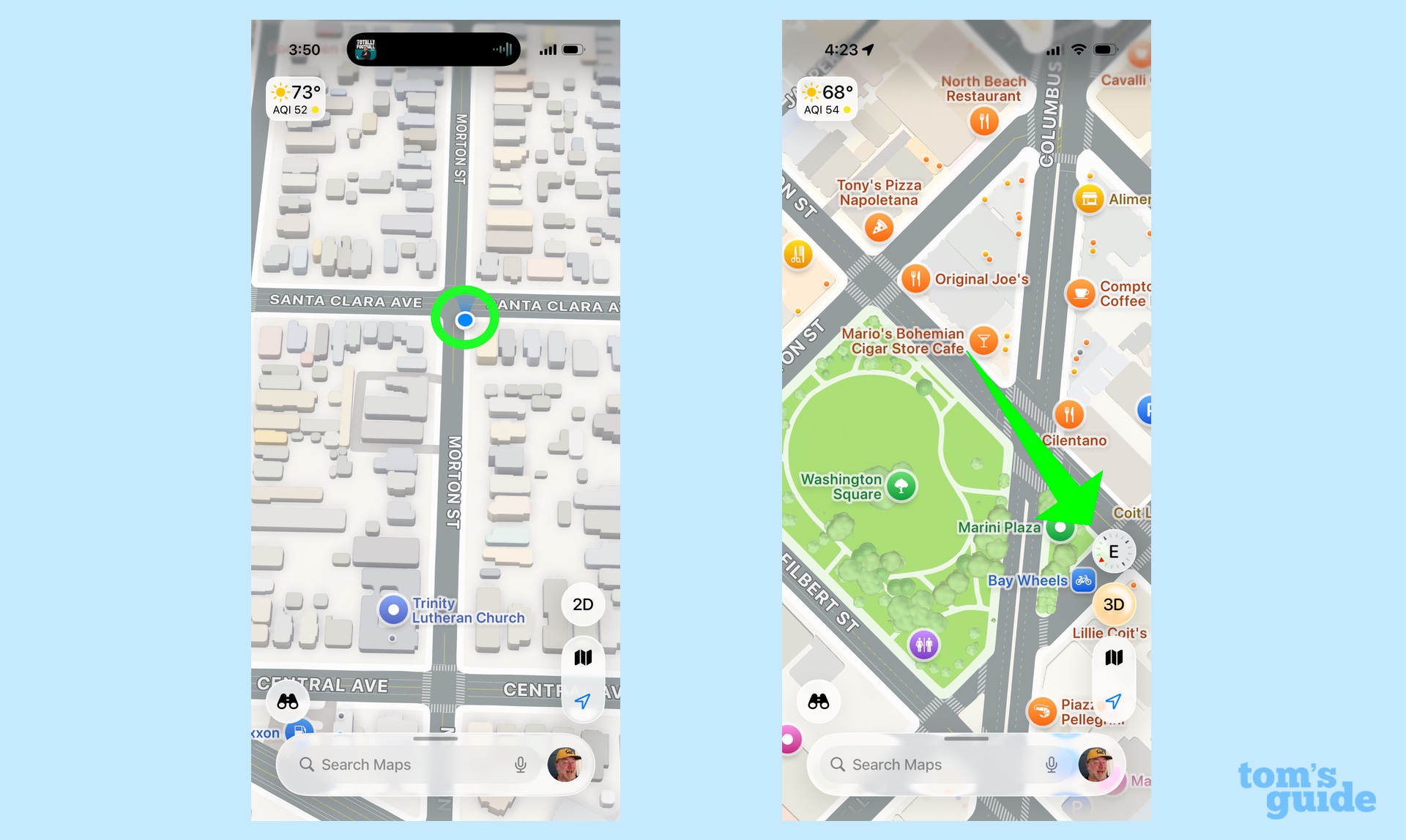
When I'm on foot, I appreciate that blue dot that appears in the Maps interface to show my location — and I'm especially appreciative of the lines radiating from it to show the direction I'm facing. In unfamiliar cities surrounded by tall buildings, it can be hard to get your bearings, but that dot becomes very useful for letting me know if I'm walking in the right direction and getting me to course-correct if I'm not.
By the way, if you've scrolled away to another part of the map, you can always return to your present location by tapping the location arrow that's off to the side of the screen just underneath the icon that displays what map view you currently have selected.
One more directional tip: if you make a two-fingered pinching gesture on a map and twist so that the orientation of the map shifts, a small compass will appear on the screen to let you know what direction you're facing. Tap the compass to make it disappear.
Where did I park?
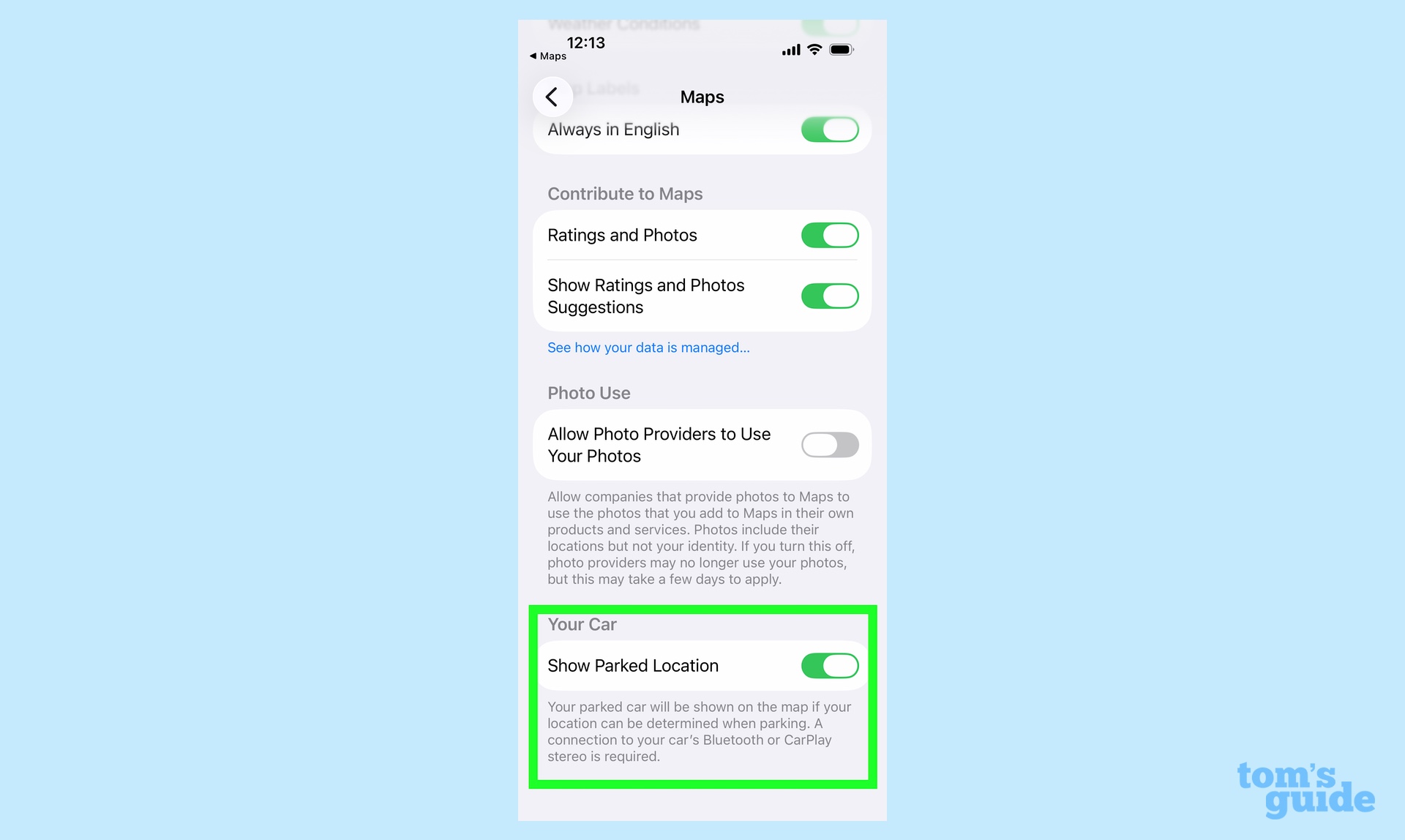
In the early days of smartphones, I thought I was being clever when my lifehack was to take a photograph of my parked car so I could refer to it later if I had a hard time remembering where I parked. But these days, I leave that task to Maps. There's a setting in the app where you can have Maps remember the location of your car so you can find your way back after that dinner or concert you've attended.
You'll need to leave the Maps app and head to Settings to turn this on. Just go to the Apps section of Settings, tap on Maps and make sure the toggle next to Show Parked Location is turned on. You will have to be connected to your car's stereo, either via Bluetooth or CarPlay, for this to work.
Follow Tom's Guide on Google News and add us as a preferred source to get our up-to-date news, analysis, and reviews in your feeds. Make sure to click the Follow button!
More from Tom's Guide
- Apple Maps vs Waze: 800-mile drive test
- I drove over 1,000 miles to test out Apple Maps vs. Google Maps for a month — here's the winner
- Apple Maps is my go-to choice for directions — here's how Apple Intelligence could make it even better
Philip Michaels is a Managing Editor at Tom's Guide. He's been covering personal technology since 1999 and was in the building when Steve Jobs showed off the iPhone for the first time. He's been evaluating smartphones since that first iPhone debuted in 2007, and he's been following phone carriers and smartphone plans since 2015. He has strong opinions about Apple, the Oakland Athletics, old movies and proper butchery techniques. Follow him at @PhilipMichaels.
You must confirm your public display name before commenting
Please logout and then login again, you will then be prompted to enter your display name.
 Club Benefits


