Google Earth celebrates its 20th anniversary with historical street view and new AI insights
Plus, a look at history from a bird's eye view

Here at Tom’s Guide our expert editors are committed to bringing you the best news, reviews and guides to help you stay informed and ahead of the curve!
You are now subscribed
Your newsletter sign-up was successful
Want to add more newsletters?

Daily (Mon-Sun)
Tom's Guide Daily
Sign up to get the latest updates on all of your favorite content! From cutting-edge tech news and the hottest streaming buzz to unbeatable deals on the best products and in-depth reviews, we’ve got you covered.

Weekly on Thursday
Tom's AI Guide
Be AI savvy with your weekly newsletter summing up all the biggest AI news you need to know. Plus, analysis from our AI editor and tips on how to use the latest AI tools!

Weekly on Friday
Tom's iGuide
Unlock the vast world of Apple news straight to your inbox. With coverage on everything from exciting product launches to essential software updates, this is your go-to source for the latest updates on all the best Apple content.

Weekly on Monday
Tom's Streaming Guide
Our weekly newsletter is expertly crafted to immerse you in the world of streaming. Stay updated on the latest releases and our top recommendations across your favorite streaming platforms.
Join the club
Get full access to premium articles, exclusive features and a growing list of member rewards.
Over the last 20 years, Google Earth has enabled us to explore the globe through billions of images from aerial photography, satellite imagery, Street View, and 3D images.
The globe explorer debuted a few months after Google Maps, but is more than just a way to get you from point A to point B.
Google claims that in the last year alone, Google Earth has been searched over 2 billion times.
To celebrate its 20th anniversary, Google Earth is introducing a pair of new features: one is available now, and the other is intended for professional users and will roll out in the coming weeks.

- Historical Street View: You can already play with historical Street View in Maps, but starting June 24, the "time travel feature" will be available directly in Google Earth.
- AI insights: Pro users will be able to access "AI-driven" insights like tree canopy coverage. The approaches can benefit urban planning.
To access the historical view in Google Earth, go to Layers and scroll down in that submenu where there is a layer called "Historical imagery." That's for the aerial and satellite imagery, though it gets quite blurry pre-2000, depending on where you look.
In Street View, you can go to a location and toggle with an arrow on the top icon to see how things have changed.
Google highlighted some big moments from the last 20 years in a blog post celebrating its birthday.
Get instant access to breaking news, the hottest reviews, great deals and helpful tips.

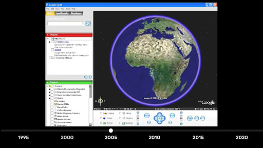
It launched in 2005 and ended up being a tool used with the National Oceanic and Atmospheric Administration that aided people after Hurricane Katrina devastated New Orleans.
Scientists and researchers used the tool to find or identify fossil sites, habitat changes and even ancient buildings.
The first historical feature launched in 2017 with Google Earth Timelapse, which lets you see how areas changed over a 35-year period.
It has become more useful for professionals in the last couple of years with data tools and tours.
Historical imagery came to Google Earth in 2024.
It's a great tool for exploring the world, and now with the history expansion, seeing how things have changed from urban growth and decay to climate change and beyond.
More from Tom's Guide
- I tested Perplexity vs Google AI overview with 7 prompts — the results were shocking
- Google just launched ‘Search Live’ — here’s why you’ll want to try it
- Google could be planning its own take on Samsung's Now Bar — what we know

Scott Younker is the West Coast Reporter at Tom’s Guide. He covers all the lastest tech news. He’s been involved in tech since 2011 at various outlets and is on an ongoing hunt to build the easiest to use home media system. When not writing about the latest devices, you are more than welcome to discuss board games or disc golf with him. He also handles all the Connections coverage on Tom's Guide and has been playing the addictive NYT game since it released.
You must confirm your public display name before commenting
Please logout and then login again, you will then be prompted to enter your display name.
 Club Benefits


