Google Maps and Waze have a lot of things in common, which makes sense considering Google is responsible for them both. But no matter how many updates happen, and how small the gap becomes, Google Maps and Waze remain very distinct as their core. And it's primarily down to the fact the two navigation apps both work in completely different ways.
Google Maps is all about the data, with years of archives to fall back on, while Waze is more focused on crowdsourcing data from other drivers — and relying on them to keep things up to date. Waze is also famous for how aggressively it can be in trying to speed up your trip, which is part of the reason it's so popular.
So when it comes down to Google Maps vs Waze, which navigation app is the best one for you?

Google Maps vs Waze: Availability
Google is well known for having a stake in most major platforms, so Google Maps and Waze are both widely available. Both apps are available on iOS and Android devices, and are compatible with Android Auto, the Android Automotive car OS and Apple CarPlay. So it doesn’t matter what kind of device you use, or what car you drive, you’ve got the option of using both.
Google Maps has a minor advantage on cars running Android Automotive OS, since it's one of the pre-installed apps on every Android device that isn't connected to a TV. Waze, meanwhile, has to be specifically installed by the user. It's only a minor setback, but it does give Google Maps a tiny edge.

There are even versions of both services available in desktop browsers, though they are limited by the fact you can’t get any live navigation that way. Still you can look up directions, locations and save things to your account, which you can pick up on your phone later on. They both even off traffic layers, letting you see the state of the roads around you, just like on mobile.
Winner: Tie
Google Maps vs Waze: Navigation
At their core, both Google Maps and Waze will get you where you want to go. That being said, despite both being operated by Google, they are pretty different. To the point where the “winner” depends entirely on how you get around.
Google Maps is your traditional navigation app. You punch in a location, and it will find a way to get you there, no matter how you plan on doing it. You could walk, drive, cycle, or take the bus, and Google Maps has something to offer. Google can even alert you to obstacles or traffic along the way, and give you the option of taking a different path.
Waze, on the other hand, is built exclusively for car and motorbike users. Rather than finding the quickest single path to your destination and leaving you to it, Waze is always analyzing conditions to try and get you there the fastest possible way. It's a running joke that Waze would tell you to drive through an active war zone to shave 5 seconds off your journey.
Both services can determine traffic conditions from the number of users on the road, but Waze actually does something about it. Google Maps will flag traffic or obstacles it knows about on-screen, as does Waze, but the difference is Google will happily send you on the same pre-set route regardless of how things change. It may ask if you want to take an alternate route depending on how bad the traffic gets, but it’s not particularly aggressive about it.
But Google Maps has changed the way it calculated its calculates its routes in recent years. The service will now use a number of factors, including real time traffic conditions and number of traffic lights, to make the proposed route safer, and more eco-friendly. That way you save on fuel, and are less likely to get into an accident.
In other words Google Maps will take more than just your final ETA into account when it tells you where to go. And more recently it even started showing you exactly how much a particular route will cost, should you pass through any tolls. A feature it pinched from Waze, we might add.

Waze is built around one thing, and one thing only: minimizing your time on the road and getting you to your destination as quickly as possible. That mean it doesn’t ask permission to alter your route mid-trip, and automatically offers up directions that get you around obstacles that have popped up. All in the name of getting you somewhere in the shortest amount of time. For that reason Waze users often find they get sent to some very random places, as the app works to get them where they need to go.
A great example of this is when I looked up directions to my parents’ house. Waze said it would be a 213 mile trip that would take 3 hours and 19 minutes. Meanwhile Google Maps provided a shorter route (211 miles), but would take 3 hours and 32 minutes to make the trip. That’s travelling the same basic route, and not avoiding toll roads.
Likewise, Waze said driving to our London office would be a 45-mile trip taking 1 hour and 12 minutes. Google Maps sent me on a 46 mile journey that was two minutes longer.
The downside to Waze’s system is that it’s reliant on other active users on the road. So if you’re the only Waze user for hundreds of miles, the app has no idea what’s going on up ahead.
Fortunately both services let you save maps offline for later use, though Google Maps is more upfront about it. Google Maps' Offline maps feature lets you select an area of the map, and download all the available data within it. Previously you could save individual routes, though this no longer appears to be the case.
Waze doesn't have either option, but saving a route to your favorites does cache the relevant information so you can use it offline. But because Waze is reliant on live data, if you do lose cell service you won’t get any up to date information about what’s happening on the roads. Basically you lose the very part of Waze that makes it special.
When it comes to driving the two services are practically identical, but Waze’s unique way of navigating around delays makes it an invaluable tool for motorists. Provided you're happy taking weird routes, Waze is the way to go.
Winner: Waze
Google Maps vs Waze: Public and Alternate Transportation
This is an easy decision to make. If you’re travelling by public transport, or some other means of alternate transportation Waze has absolutely nothing to offer. Literally nothing.
The point of Waze is to redirect you as a driver whenever it sees a faster route round obstacles, but obviously you don’t have that luxury on public transit because you’re not the one driving. So you’re going to have to use Google Maps.

Google Maps has support for public transportation, walking and cycling. Attempting to use Waze would just send you down any old route as a car can get down there, which isn’t always a particularly safe idea.
Google Maps, on the other hand, is packed to the brim with public transit information. For starters it includes full timetables and maps for transit services across the world, and can integrate them into its directions without hesitation. It also has real time updates on delays and other issues you may face on your journey, so you’re at least aware of problems ahead of time.
Google Maps can also estimate how busy a particular service or area is going to be, by using a mix of historical data and how many people it can see there at any given time. It even integrates with local ride sharing services and, where available, bike and e-scooter rentals.
Waze can’t compete with all of that, but there is more that could be done where alternative transport is concerned. Especially in areas where those rental services are available.
Winner: Google Maps
Google Maps vs Waze: Interface and Design
Despite being from the same company, and doing similar things, Google Maps and Waze look completely different. While Google Maps has the look of a more traditional app with all the on-screen information that provides, Waze takes a much simpler approach with fewer details and a cartoony design.
That difference comes from the fact these two apps are designed for totally different things. Waze is a tool to help motorists get from A to B while avoiding traffic and road hazards, but nothing else. Google Maps is useful for damn-near everything, whether that’s navigation, discovering new things, or even chatting with businesses.
However, when it comes to actually navigating, the two apps look functionally identical. The apps cut down all the unnecessary clutter, and just show you what you need to know. That includes your icon, where you need to be going, plus some extra surplus information like speed limits, and road hazards in your path.

We have to give this one to Waze, because it cuts out all the fluff from the get-go and only shows you what you need to see. It doesn’t matter if you’re actively receiving directions or just looking at the map, everything is nice and clean. While Google Maps’ extra information has its uses, it does tend to clutter your view. And frankly it has a tendency to look like a complete mess at times — especially if you’re in a big city.
Winner: Waze
Google Maps vs Waze: Advertising
Both Google Maps and Waze have advertising, though they each differ in how they handle what sort of paid content you actually see.
As a general rule, Google Maps is pretty subtle about its advertising, though more recently it has made changes to make ads more distinguishable on the map. One good example is using a square icon, rather than a circular one, for a business or location that's paid to be there. Pretty subtle, as I said.
Meanwhile Waze is very in your face and can flash distracting banner ads every time you stop moving. There was some fear that Google could do something similar, but the official line is that this isn't the case.

The ads disappear when you start moving again, so you don’t have to worry about dismissing them all the time. But they are still large and very noticeable, especially if your phone’s screen is on the smaller size. Frankly Waze could do with toning it down a bit, because if it needs to display ads the least it could do is try to make them less intrusive.
Winner: Google Maps
Google Maps vs Waze: Data
Google Maps and Waze are both heavily reliant on data, but Waze most of all. That’s because Waze’s entire operation is built around user-submitted information. A lot of it is collected automatically, just by the simple fact that you are driving around with the app open.
Users are also able to submit reports about any obstacles or hazards that may impede other drivers. Both apps have made strides to improve this in recent years, with Google especially adopting a more Waze-like approach. This includes having more on-screen reporting options.
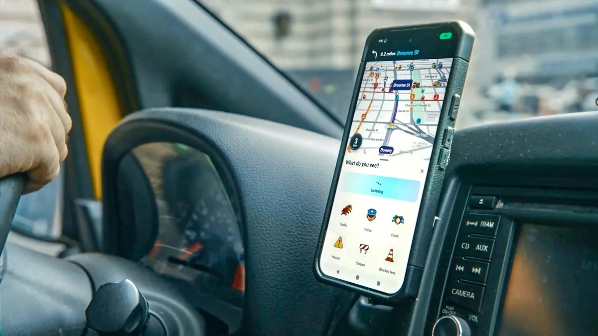
However Waze is set to add Gemini into the mix, offering a new "Conversational Reporting" feature that doesn't rely on using exact voice commands. Which should let driver focus more of their attention on the road, while still being able to report hazards to the community.
Analysis of all that information paints a picture of what is going on on the roads, and can be utilized to direct or redirect users where necessary. It also helps Waze’s algorithms improve the service and its maps.
Google Maps can also see a picture of road conditions, but its system is based on a larger pool of information. It uses historical data to guess what conditions will be like at any given point of the day, but is also able to pull in real time information from traffic sensors and Google Maps users. The systems have similarities, though Google Maps is able to make use of a lot more information than Waze does.
For that reason it doesn’t matter if you stray into an area with few Google Maps users. The app will be able to see what’s going on based on other factors, and keep you relatively well informed.
Of course Google Maps and Waze utilize their data very differently. While Waze will actively redirect your journey based on the data it receives, it’s a feature that still hasn’t been ported to Google Maps, even though both services are owned and operated by Google.
You can keep tabs on upcoming road conditions if you pay attention to what Google Maps has on screen, and sometimes it will offer faster routes if they're avialable. But it’s generally up to you to select those alternate routes and opt-in if they flash up, Ignoring the prompt means you'll stay on the original route. So Google Maps will not automatically send you down a different path the same way Waze does. But more on that later.

But years of data collection and analysis come with a lot of advantages. Google Maps knows how many people are likely to be using a particular routes at any given period of the day, and even areas where people typically drive over the speed limit.
Barring any external factors that get in the way after you’ve already set off, Google Maps always has a pretty good idea of which route you should take and how long it’s going to take you to reach your destination. While Waze has a lot going for it, that lack of historical and traffic sensor data does not work in its favor.
Winner: Google Maps
Google Maps vs Waze: Discovery
Despite the fact Waze is primarily a navigational app, it has surprisingly robust discovery features that match those found in Google Maps.
Both apps have a number of similar features helping you find important businesses and locations in the area around you. They include a search bar and specialized buttons that take out most of the intermediary steps and show you what’s what. Whether you’re looking for a gas station or a supermarket, you have the tools to quickly find them and get there.
But as often seems to be the case, Google Maps is all about giving you more. It features a larger number of specialized buttons. So if you need sporting goods or an electronics store, Google Maps’ list of discovery buttons has something. Waze, on the other hand, keeps it simple.
You could easily argue less is more when it comes to finding stuff, especially when you can always use the search bar to do roughly the same job. However, Waze’s location cards don’t have quite as much information as Google Maps does.

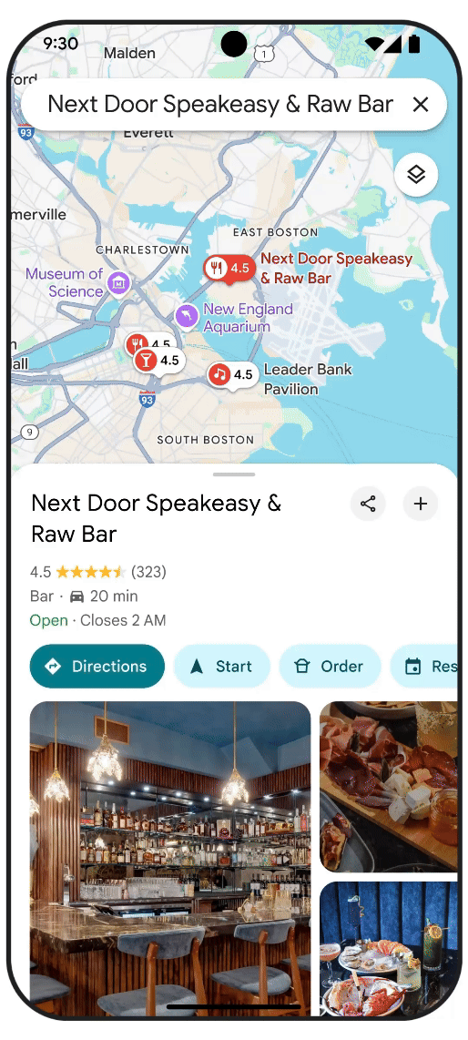
My local Chinese restaurant is a great example of this. Google Maps has the address, opening hours, contact information, reviews, photos of the food people have submitted, and even icons telling me what services they’re currently offering.
Waze had information on the nearest car park, which was great, but beyond that it only had the basics: address, phone number, and website. Other smaller businesses around me had similar issues, but there’s a lot more to be seen for big chains.
My nearest McDonalds had opening hours and onsite-service icons (drive thru only right now), but no contact information — including the website. You’d have thought it was the least they could include. The TGI Fridays five miles up the road was the same.
Both services are also able to let you search for EV chargers, though Google's pushed through some updates that should make it even easier to find a compatible DC rapid charger for your car mid-drive.
Google Maps doesn’t have everything for everyone, but it still manages to pick up a lot. One of the takeout places near me has zero online presence — not even a website telling you where they are. Despite that Google Maps still has a lot of information, including when they’re open, what their phone number is, and even when they get busy.
So Waze is very hit and miss with extra information, while Google Maps has almost everything you could hope for because it collects so much data from so many different sources.
It's also not clear whether Waze's discovery options will be getting the same improvements that were announced for Google Maps back in May. Those recommendations are going to be a lot more focussed, with time of day factoring into what Google Maps has to show you. So we'll have to wait and see.
Winner: Google Maps
Google Maps vs Waze: Traffic and hazards
Back in the day, having a handle on traffic and road hazards was all on Waze, but Google Maps has been catching up. Right now the two are functionally the same in all but a few minor areas.
Waze is very aggressive at getting you round obstacles other users have reported. To the point where you can find yourself driving down strange winding streets just to shave a few seconds off your ETA. You have to admire its dedication. Google Maps still doesn’t go to such extreme lengths which is fine.

While Google Maps and Waze both let you report those hazards as you come across them, they don’t always match up, especially if you’re using Google Maps. For instance the stretch of freeway that takes me into London is almost completely covered in speed cameras. There has to be at least one camera every mile enforcing a strict 50mph speed limit. Waze has little graphics for most of those cameras, and flashes up an on-screen warning every time I drive past one.
Meanwhile Google Maps does a pretty terrible job of both. Google Maps lets you report speed cameras, and other serious road hazards, but on the 45 mile trip from my house to London it showed a grand total of two cameras. Waze doesn’t seem to have them all, but it has a heck of a lot more than Google Maps. You’d think Google’s data collection machine would be more accurate than Waze’s crowdsourced approach.
Granted Google Maps isn’t far behind, but Waze does have the edge on account of the fact its user base isn’t quite as passive.
Winner: Waze
Google Maps vs Waze: AI
Google has been investing heavily in AI across its entire platform, but so far both Google Maps and Waze haven't had a great deal of attention in this area. That's not to say there's no AI support in the apps, just that there may be less than you'd expect right now. But this is already changing, and the number of AI features is slowly growing.
Google Maps is the flagship product and has gotten the most attention so far, and there hasn't been a lot of overlap with Waze. In fact Waze has only received a single AI boost over the past couple of years, with the launch of a feature called "Crash History Alerts".
This is a safety feature designed to inform drivers when they're approaching a spot of road known for crashes and similar accidents. Powered by an algorithm, it utilizes past data alongside current road conditions (like traffic and the number of curves) to determine whether the driver needs to know. That way they know to take extra care, and hopefully help reduce the number of crashes going forward.
Waze is also expected to get some Gemini support with "Conversational Reporting". The idea here is to improve Waze's all-important incident reporting feature, and allow users to submit those reports with natural voice commands — rather than commands that are static and hard to remember. Hopefully ensuring that they can then keep their eyes and attention on the road ahead.
Gemini will be along for the ride in Google Maps too, though maybe not in the same way as Waze. While Waze utilizes Gemini to make sure incident reporting is understood, Google Maps is using conversational AI features to help you communicate with Google Maps in a more natural way. Like Asking "what's around me" or "what can I do".
Without AI Google Maps wouldn't be able to help you out. Since Large Language Models can understand what you mean, it lets you communicate with Google Maps in a whole new way.
Gemini is also able to summarize verified reviews, so you can figure out whether a spot is worth your time or not, while also offering drivers more navigation options beyond driving from A to B. This includes generating a list of landmarks and places of interest along driving routes.

Google Maps has also seen generative AI employed in its discovery feature, letting you ask for very broad or incredibly niche locations without leaving you with no place to go. All while letting you use more natural search queries without being misunderstood.
Essentially the AI analyzes all the information Google Maps has on spots in the area to help you pick a place that's suitable for you. results are then filtered by category, with reviews and photo galleries to help you figure out a place to eat. Naturally being AI, it's able to link between different search requests and potentially help you find new spots that are related.
This same AI is also being utilized to help drivers find EV chargers in both Google Maps and Search.
Street View has also picked up a new trick by integrating Google Lens. Lens in Maps, as it's called, lets you view the world around you and offer up information and recommendations about local businesses and restaurants.

Finally there is Immersive View, an AI-powered feature that can create 3D representations of select cities round the world. The goal of this is to let people experience an unfamiliar area in a more personal way, beyond what Street View alone can accomplish.
Recently Google also upgraded Immersive View with a new Routes feature, which is designed for future navigation. With it Google Maps takes into account forecast weather and predicted traffic conditions to show you what this area may be like in the near future. Helping you figure out where to go in a more natural way.
While there's certainly potential for both Waze and Google Maps to integrate AI in new ways going forward, it's clear right now that Google Maps has the upper hand. Primarily down to the fact it has more features in general, allowing for more AI support to happen.
Winner: Google Maps
Google Maps vs Waze: Hands-free control
Both Google Maps and Waze operate their hands-free controls in the same way. Your options are to tap the on-screen microphone each time you want to say a command, or rely on Google Assistant’s “Hey Google” feature to do it for you.
If you’re on Android that’s easy, because Google Assistant is already installed. iPhone users have to go through some extra steps. Siri will send commands to both apps, but it also defaults to Apple Maps if you don’t specify. So ask for “directions home with Waze,” and not just “directions home.” Alternatively you can tap the on-screen microphone to toggle voice command mode, or download Google Assistant to do everything for you.
Google Maps will also let you deactivate the "Hey Siri" command while the app is open, in the Navigation section of the settings menu. That means you can use the "Ok Google" command as if you were on Android.
Presumably, at some point in the near future, we'll also see Gemini come to Google Maps and make conversing with the app a lot easier. Both on your phone and through CarPlay and Android Auto. However we'll have to wait and see how that plays out, and whether Waze follows suit.

There doesn’t appear to be any difference between the two apps in terms of commands, and you can use an assistant to navigate to new locations, alter your current route, see what’s up ahead, what traffic is like, and so on. You can even use voice commands to report road hazards, traffic, and other issues you come across on your travels. These features are also available on iOS if you have the Google Assistant app installed.
So it doesn’t matter which option you take, or which device you use, your experience should be pretty much identical.
Winner: Tie
Google Maps vs Waze: Customization
Waze has a lot of customization options, particularly in the voice section. While Google typically only has one voice option per country or region, Waze has several of them, especially if you speak English.
Celebrity voices are also available, but those are typically there for promotional purposes and aren’t permanent additions to the app. Like the time Microsoft and Waze added the voice of Halo's Master Chief. Plus, if you refuse to take orders from a random robot, Waze will let you record your own voice to use instead.
Waze will also let you pick one of ten vehicle icons that show on screen when you’re actually navigating, including a Formula One race car, a motorbike, or the boring-old arrow. Plus you can change your “mood” which essentially lets you customize the avatar other people will see on their own maps. Drive enough, or contribute enough to Waze’s dataset, and you can unlock a special mood that features a golden crown.
Google Maps lets you change your on-screen icon to one of three cars if you like, and you can switch the voice to a different language or region. But that’s about all it has in terms of actual customization options. But if you fancy driving around with a kindly British robot telling you where to go then that’s an option for you.

Customization is a very small part of what both apps can do, but if you want to better express yourself through your navigation app then Waze is the way to go. Likewise Waze is the best option if you want to mix things up and swap out the boring default voice.
Winner: Waze
| Row 0 - Cell 0 | Google Maps | Waze |
| Availability | x | x |
| Interface and Design | Row 2 - Cell 1 | x |
| Navigation (Driving) | Row 3 - Cell 1 | x |
| Public and Alternate Transportation | x | Row 4 - Cell 2 |
| Advertising | x | Row 5 - Cell 2 |
| Data | x | Row 6 - Cell 2 |
| Discovery | x | Row 7 - Cell 2 |
| Traffic and hazards | Row 8 - Cell 1 | x |
| AI | x | Row 9 - Cell 2 |
| Hands-free control | x | x |
| Customization | Row 11 - Cell 1 | x |
| Total | 7 | 6 |
Google Maps vs Waze: Verdict
There’s no denying the fact that Google Maps is the more comprehensive navigation service. Not only does it offer a considerable amount more than Waze, it’s more detailed and has a lot more resources at its disposal. More to the point, it doesn’t matter how you choose to get around, Google Maps has the tools to help you do it.
Waze is very limited by comparison, only offering navigation for motorists. And yet it’s able to offer a service that Google Maps can’t match, which is pretty damn weird considering how long it’s been part of the Google family. Why? It's not entirely clear what Google has to gain from keeping both services alive, and not offering Waze's breakout feature as part of Google Maps. But that is how things are.
If you’re a driver who wants to get to their destination as quickly as possible, and don’t care how you get there, you’ll want to use Waze. Google Maps may be able to see and anticipate road conditions, but it isn’t as proactive about sending you down a different route when things get dicey.
But if you’re not driving a car or motorbike, Waze is completely useless. It has a very narrow use-case, which is a void Google Maps fills very easily. So in many cases, Google Maps isn’t just the winner, it’s your only option.