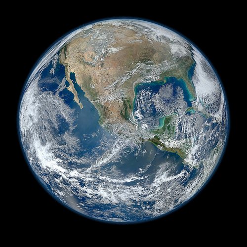
NASA Releases Amazing 64-MP 8000x8000 Photo of Earth
There's no place like home.
NASA has released a breath-taking high-definition image of our fair planet from space. The 64-megapixel image was captured by the VIIRS instrument aboard NASA's most recently launched Earth-observing satellite - Suomi NPP. According to NASA, the image is a a composite that uses a number of swaths of the Earth's surface taken on January 4, 2012.

This isn't the first time NASA has released a high-resolution image of the Earth as seen from space. The first (and arguably most famous) was taken by Apollo 17 and is known as the Blue Marble photo. NASA has released several photos along the same vein since then, including Blue Marble 2002, which many will recognize as the oh-so-familiar iPhone lock image.
Hit up NASA's Flickr to get the full-size version.
[UPDATE] For those that want to compare 2012's Blue Marble with the Blue Marble imagery produced in 1972, and 2002, you might want to check out NASA's History of the Blue Marble. This also includes more information (and examples) from NASA's Blue Marble: Next Generation project. This took place in 2006 and, similar to the other Blue Marble images, is a mosaic of satellite data taken mostly from a NASA sensor called the Moderate Resolution Imaging Spectroradiometer (MODIS) that flies board NASA’s Terra and Aqua satellites. However, while the older Blue Marble was a composite of four months of MODIS observations with a spatial resolution of 1 square kilometer per pixel, Blue Marble: Next Generation offers a year’s worth of monthly composites at a spatial resolution of 500 meters. This means you can see the vegetation flaring up and dying off with the change of the seasons, dry and wet seasons in the tropics, and advancing and retreating Northern Hemisphere snow cover. For more on Blue Marble: Next Generation, click here.
Follow @JaneMcEntegart on Twitter for the latest news.
Get instant access to breaking news, the hottest reviews, great deals and helpful tips.
Jane McEntegart works in marketing communications at Intel and was previously Manager of Content Marketing at ASUS North America. Before that, she worked for more than seven years at Tom's Guide and Tom's Hardware, holding such roles as Contributing Editor and Senior News Editor and writing about everything from smartphones to tablets and games consoles.
-
jonpaul37 I wonder what that same picture must have looked like 500 years ago, was probably alot more green.Reply -
Specter0420 Can we get some 16x9 and 16x10 sizes? I can do it just not at work. It looks oval on my screen.Reply -
Nakal But it has to be fake, you cannot see the stars! (well at least that is what the fake moon landing people say....)Reply -
acadia11 If that isn't the creation of god I don't know what is.Reply
Sincerely, certified athiest. -
acrufox Remember this was taken in January 4th which is during the wintertime so I wouldn't expect much green at this time of year. lolReply -
acadia11 greghomeI'd prefer if they had taken a picture of Africa North America looks so boring and dryReply
Got to agree on that one. World's biggest continent has way way more features of interest, although, the great lakes are pretty nice in the North America.
The US looks like 1 giant plain from space. -
joytech22 Now I want to see a gigapixel resolution image of this.. :DReply
There's a whole website dedicated to gigapixel photo's and it would be awesome to see one of the Earth. -
memadmax Specter0420Can we get some 16x9 and 16x10 sizes? I can do it just not at work. It looks oval on my screen.Reply
Select Picture position: Fit, when setting it as desktop background(in control panel)
 Club Benefits


